Ministry of Natural Resources and Environment (MNRE), Samoa
… … … Ministry of Natural Resources and Environment (MNRE), Samoa … samoa … disaster … pcarifi … assessment … Atmosphere and …
Ministry of Natural Resources and Environment (MNRE), Samoa
… This data is basic contextual open GIS data for Samoa … … Ministry of Natural Resources and Environment (MNRE), Samoa … Biodiversity … Coastal and Marine …
… Link to the Samoa's datasets hosted on GBIF website … html … …
… The exclusive economic zone of Samoa comprises those areas of the sea, sea bed, and subsoil …
Ministry of Natural Resources and Environment (MNRE), Samoa
… to access **invasive species - related information** for Samoa on the 'Battler Resource Base'. It is a platform to … … … Ministry of Natural Resources and Environment (MNRE), Samoa … invasive species … battler resource base … …
Ministry of Natural Resources and Environment (MNRE), Samoa
… This dataset provides internet links to Samoa's data hosted on the GBIF website / records. … … Ministry of Natural Resources and Environment (MNRE), Samoa … gbif … samoa … species … biodiversity … Land … Biodiversity … …
2xhtml
Ministry of Natural Resources and Environment (MNRE), Samoa
… Dataset that provides a direct internet link to Samoa's climate change data portal … … Ministry of Natural Resources and Environment (MNRE), Samoa … iclim … climate … climate change … climate change …
… Direct link to all of Samoa's species occurrences on GBIF records … html … …
… direct internet link to Samoa's climate change data portal. … html … …
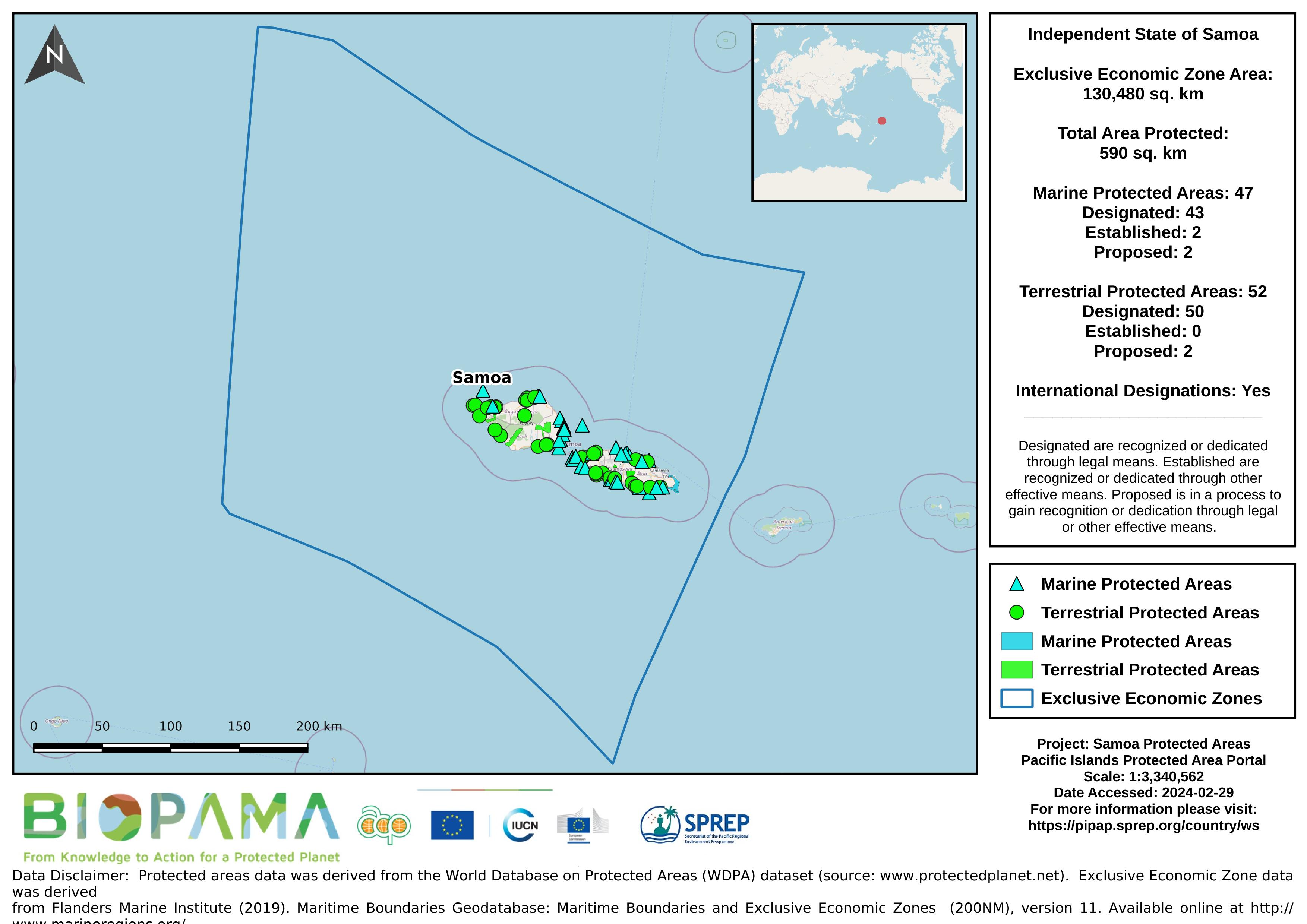
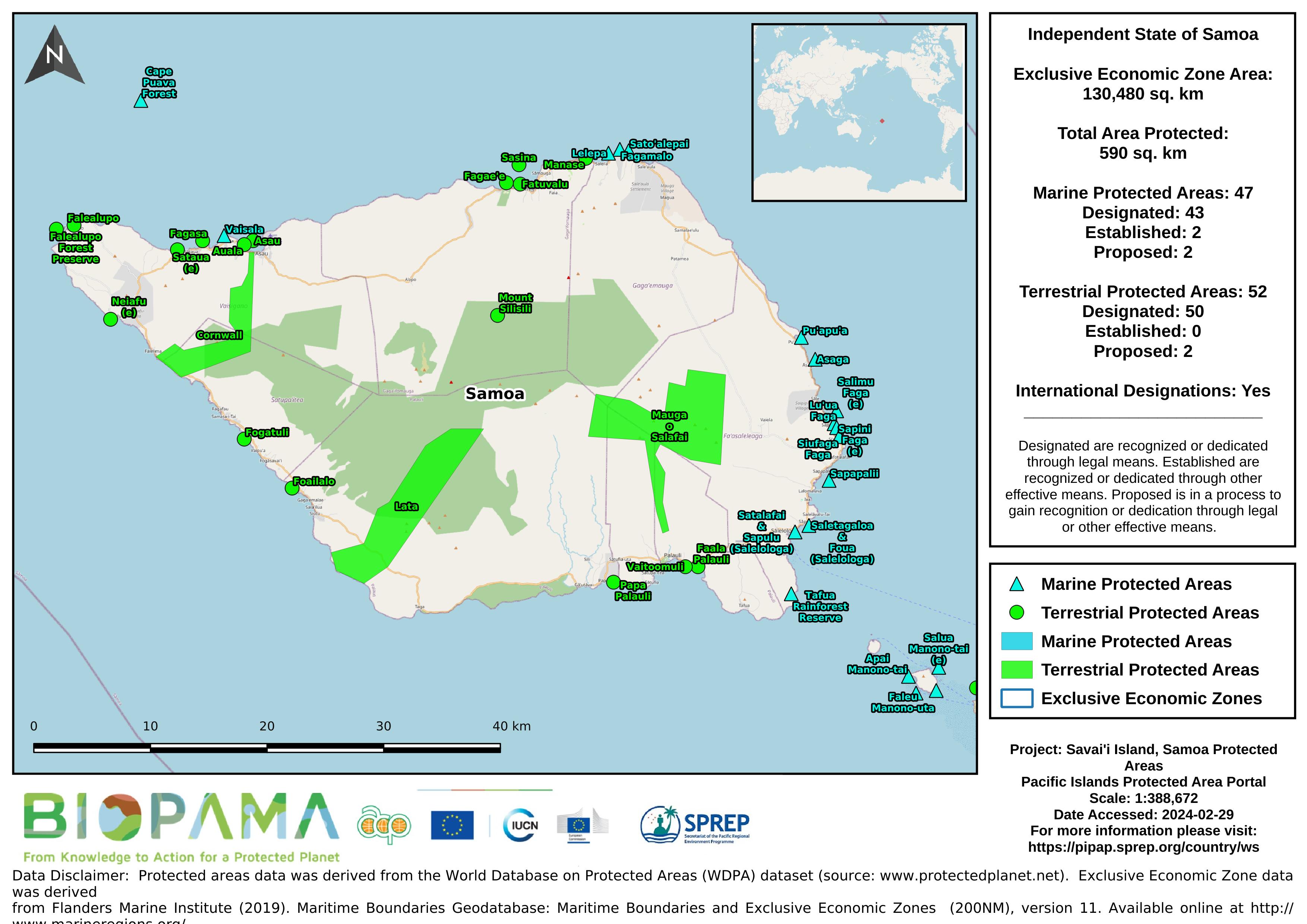
… Map of the protected areas for Samoa with country-level summary statistics on the amount of …
WSM_SPREP_PIPAP_Samoa_ProtectedAreasMap.jpeg
(616.35 KB)
SPREP Environmental Monitoring and Governance (EMG)
… This dataset is an extract of OpenStreetMap data for Samoa in a GIS-friendly format. The OSM data has been split …
Access to resources for practitioners in their battle against invasive species.
Link to download a zip file containing OSM spatial files, a QGIS project, styles, license file and documentation on how to get started.
Ministry of Natural Resources and Environment (MNRE), Samoa
… to help strengthen and enhance good waste practices in Samoa. … … Ministry of Natural Resources and Environment (MNRE), Samoa … marine … debris … marine debris … samoa … waste practices … ocean health … waste management … …
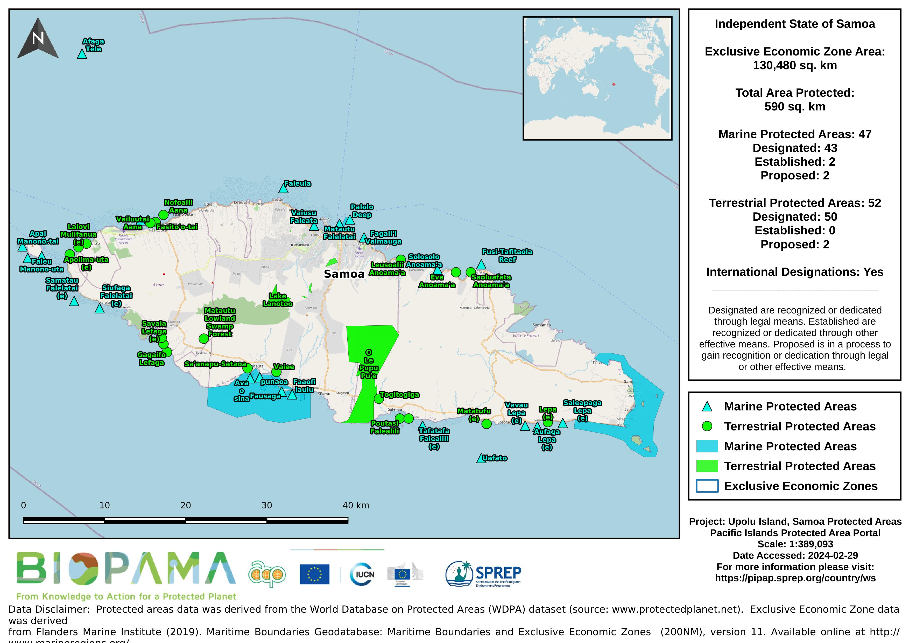
… Map of the protected areas for Upolu in Samoa with country-level summary statistics on the amount of …
… contains mapped point locations for protected areas within Samoa. This dataset should be viewed in combination with the … to get a comprehensive view of all protected areas within Samoa. … zip … …
… mapped polygon locations for protected areas within Samoa. This dataset should be viewed in combination with the … to get a comprehensive view of all protected areas within Samoa. … zip … …
Secretariat of the Pacific Regional Environment Programme
SENTINEL-2 is a wide-swath, high-resolution, multi-spectral imaging mission, supporting Copernicus Land Monitoring studies, including the monitoring of vegetation, soil and water cover, as well as observation of inland waterways and coastal areas.
The SENTINEL-2 Multispectral Instrument (MSI) samples 13 spectral bands: four bands at 10 metres, six bands at 20 metres and three bands at 60 metres spatial resolution.
… contains satellite imagery for the Independent State of Samoa. The imagery was collected on March 11, 2018, August 8, …