GOA-ON works to improve our understanding of global ocean acidification conditions and ecosystem responses by making ocean acidification data easily accessible. This data portal contains platforms and products measuring ocean acidification parameters around the world.
A recently published paper, titled “Coastal proximity of populations in 22 Pacific Island Countries and Territories” details the methodology used to undertake the analysis and presents the findings. **Purpose** * This analysis aims to estimate populations settled in coastal areas in 22 Pacific Island Countries and Territories (PICTS) using the data currently available. In addition to the coastal population estimates, the study compares the results obtained from the use of national population datasets (census) with those derived from the use of global population grids.
Polystyrene constitutes the largest waste category which supports the governments plans to ban polystyrene food packaging, cups and plates in 2020. **data extracted from the excel sheet**
Direct link to visualizations of waste items collected by %.
The four long term outcomes are:
a) Long Term Outcome 1: Sustainable management and development of natural resources and environment improved;
b) Long Term Outcome 2: A more sustainable and resilient built environment;
c) Long Term Outcome 3: Climate Change and Disaster Risk Management mainstreamed across all sectors; and,
d) Long Term Outcome 4: Effective enabling environment.
This dataset contains mapped point locations for protected areas within Samoa. This dataset should be viewed in combination with the World Database on Protected Areas polygon locations to get a comprehensive view of all protected areas within Samoa.
This dataset contains mapped point locations for protected areas within Samoa. This dataset should be viewed in combination with the World Database on Protected Areas polygon locations to get a comprehensive view of all protected areas within Samoa.
This dataset contains mapped polygon locations for protected areas within Samoa. This dataset should be viewed in combination with the World Database on Protected Areas point locations to get a comprehensive view of all protected areas within Samoa.
This dataset contains mapped polygon locations for protected areas within Samoa. This dataset should be viewed in combination with the World Database on Protected Areas point locations to get a comprehensive view of all protected areas within Samoa.
The WDPA User Manual provides information and guidance about the data held within the WDPA, including its history, how it is collected, managed and distributed, and how it should be interpreted and used for analyses and research. The Manual has been prepared for WDPA data providers and users. It is structured in 4 sections and includes 6 appendices.
The Protected Areas Working Group (PAWG) of the Pacific Islands Round Table for Nature Conservation recommended a forum to better connect a diverse range of people and their work relating to protected and conserved areas. To increase efficacy with respect to gaining momentum with communications and conservation work, the Pacific Islands Protected Area Portal (PIPAP) was launched.
This resource contains satellite imagery for the Independent State of Samoa. The imagery was collected on March 11, 2018, August 8, 2018, October 12, 2019, and June 18, 2020.
More specially, this resource contains a raster file of RGB imagery at 10-meter resolution, using Level-2A products when available. Level-2A products include atmospheric correction and represent bottom of atmosphere reflectance values in the images. When Level-2A products were not available, Level-1C (top of atmosphere) products were used.
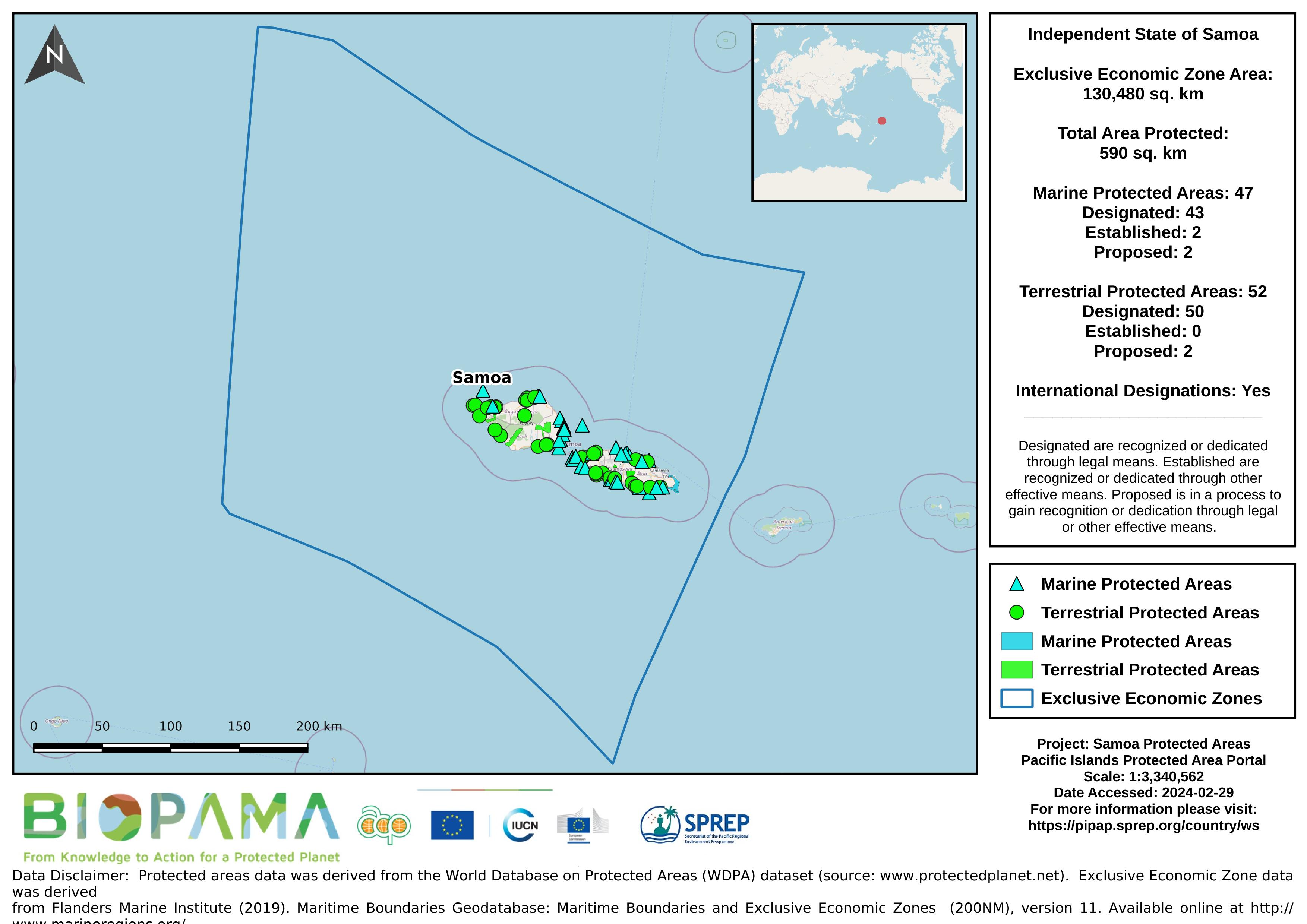
Map of the protected areas for Samoa with country-level summary statistics on the amount of area under protection, count for each type of protected area (terrestrial or marine), and the count of their designation.
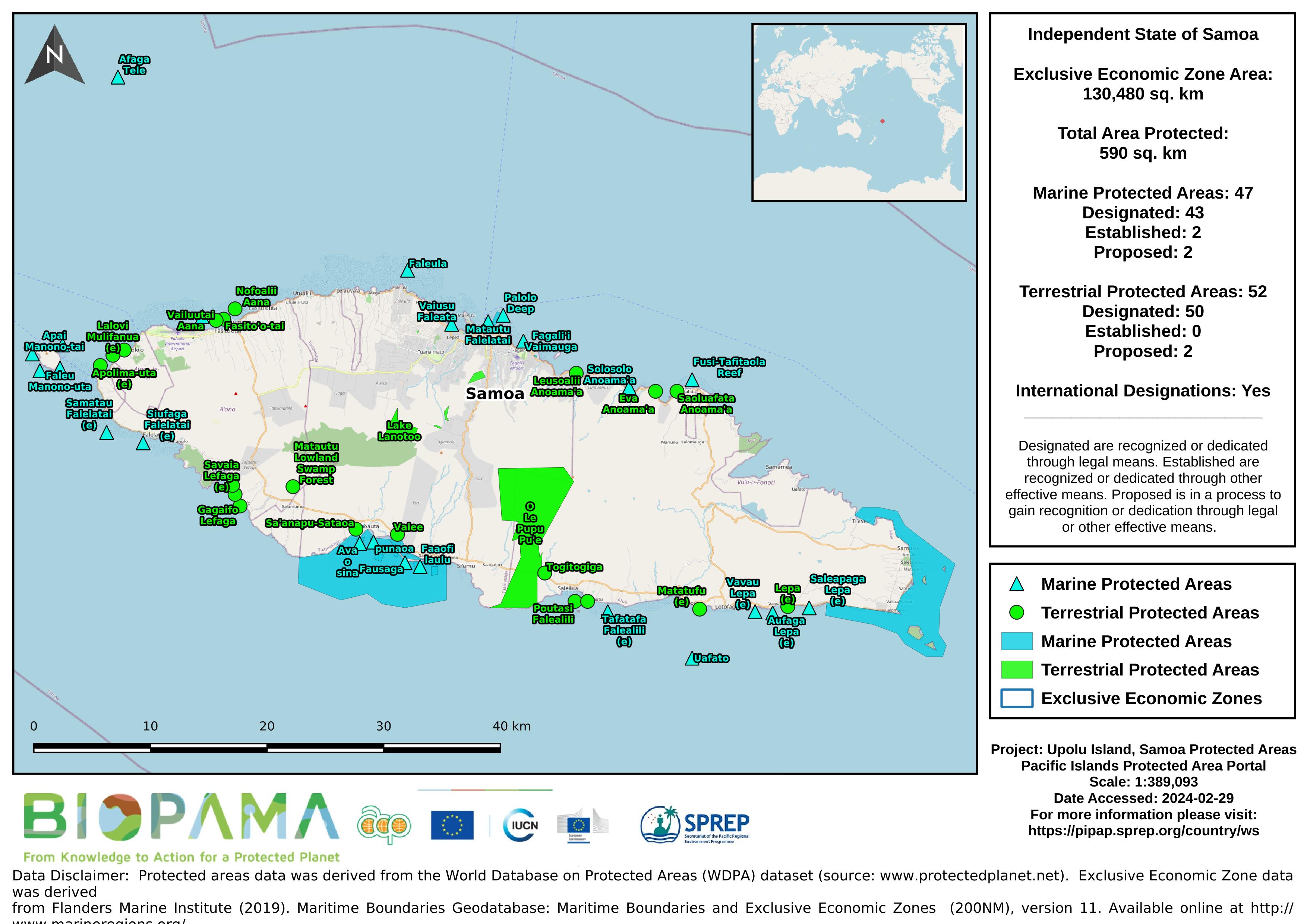
Map of the protected areas for Upolu in Samoa with country-level summary statistics on the amount of area under protection, count for each type of protected area (terrestrial or marine), and the count of their designation.
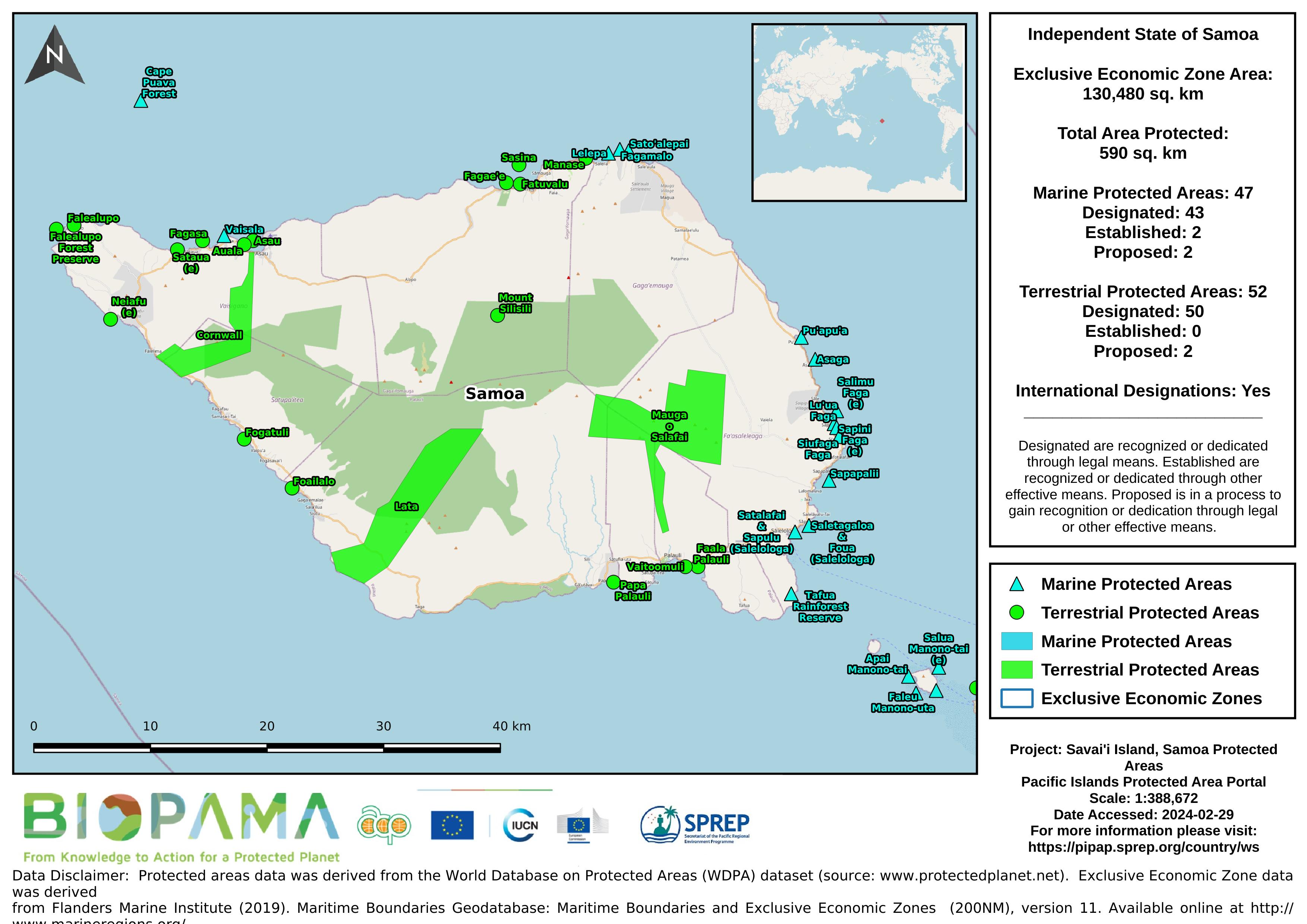
Map of the protected areas for Savai'i in Samoa with country-level summary statistics on the amount of area under protection, count for each type of protected area (terrestrial or marine), and the count of their designation.
Map of the protected areas for Samoa with country-level summary statistics on the amount of area under protection, count for each type of protected area (terrestrial or marine), and the count of their designation.
Map of the protected areas for Upolu in Samoa with country-level summary statistics on the amount of area under protection, count for each type of protected area (terrestrial or marine), and the count of their designation.
Lecture on the country-specific data and QGIS overview.
Lecture on the fundamentals of GPS devices and systems and how to set coordinate systems.