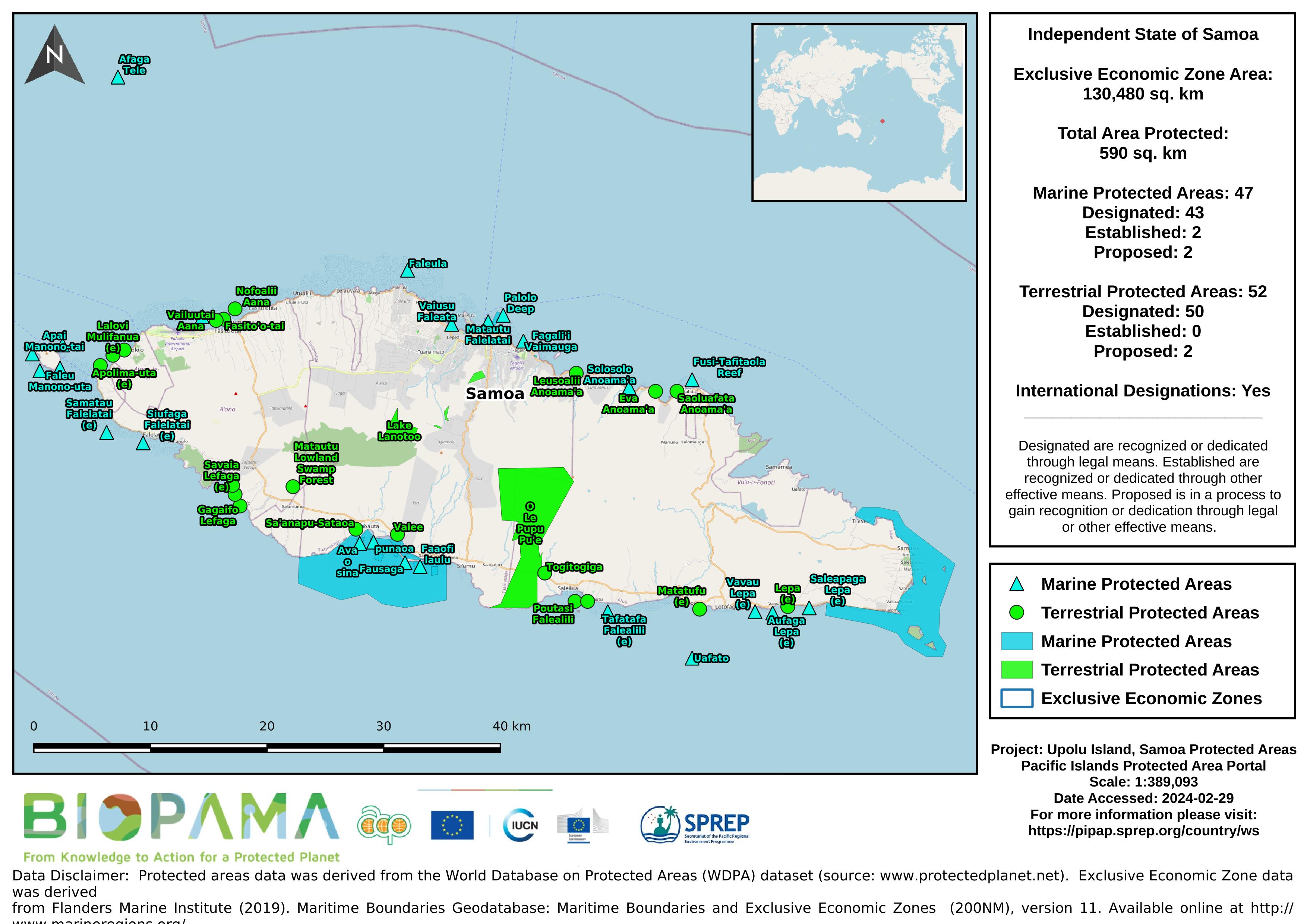
Map of the protected areas for Upolu in Samoa with country-level summary statistics on the amount of area under protection, count for each type of protected area (terrestrial or marine), and the count of their designation.
Lecture on the country-specific data and QGIS overview.
Lecture on the fundamentals of GPS devices and systems and how to set coordinate systems.
GIS datasets that are used in the exercises for the PIPAP GIS training.
Workbook containing exercises on viewing data, creating/editing datasets, producing maps, and importing GPS data using country-specific datasets to aid in the collection and mapping of protected areas.
Presented delivered Mr. Clark Duseigner ( GIS Officer) on the use of GIS in EPC, Samoa.
Presentation delivered by Ms. To'oa Brown on the use and application of GIS in the local based agriculture project (MGP-SAFPROM implemented by the Ministry of Agriculture
Presentation delivered by Mr. Paul Anderson (SPREP UNEP-GEF Inform Project Manager) on GIS and decision making as well as the existence of this platform (Environment Data Portal)
Presentation delivered by Mr. Unasa Nomeneta Saili from SkyEye on the use of GIS for the Measles nation-wide vaccination programme in 2019
Presentation delivered by Mr. Nomeneta Saili from Skyeye on the application of GIS to identify EPC assets that were damaged during the 2009 tsunami
Presentation delivered by Mr. Unasa Nomeneta Saili of SkyEye on the future for GIS for Samoa
Presentation delivered by Mr.James Atherton (vice president of Samoa Conservation Society) on the history and background of GIS and remote sensing in Samoa
An introductory presentation on what FOSS4G stands for and how the conference emerged.
The increased demand for high quality products in export markets, coupled with Pacific Island Countries (PICs) national desire to protect the environment, biodiversity and family farming structures, lead to assume that organic agriculture could offer good prospects for PICs development. Besides market opportunities, organic agriculture could increase PICs food self-reliance and thus, contribute to reducing the alarming trend of dependency on food imports, as well as improving nutrition.
A Public Data License Agreement available for use by PICs for their Environment Data Portals
For the Ninth Pacific Islands Conference on Nature Conservation and Protected Areas December 2013, Secretariat of the Pacific Regional Environment Programme (SPREP) commissioned an assessment of the status of biodiversity and conservation in Oceania. This report assesses the overall state of conservation in Samoa using 16 indicators.
*this report wasn't published but was sent to country for checking (2013) *- to be used for the Regional SOE initiative 2019
FAO Agriculture and Fair Trade in Pacific Island Countries. This desk study has been prepared by Winnie Fay Bell and comments were kindly provided by the Pacific Regional Organic Task Force in May 2009
License agreements with summary table and user guide for PICs Environmental Data Portals
The Bycatch Management Information System (BMIS) focuses on bycatch mitigation and management in oceanic tuna and billfish fisheries*. It is an open resource useful for fishery managers, fishers, scientists, observers, educators and anyone with an interest in fisheries management. As a reference and educational tool, the BMIS aims to support the adoption and implementation of science-based management measures so that bycatch is managed comprehensively and sustainably.